| Photograph Information |
Photographer's Comments |
Camera: Olympus E-1
Lens: Olympus 14-54mm f/2.8-3.5 Zuiko Digital Zoom
Location: Bayonne NJ
Date: Jan 21, 2006
Aperture: f5
ISO: 100
Shutter: 1 sec
Galleries: Landscape, Architecture
Date Uploaded: Jan 25, 2006
Viewed: 2113
Comments: 3
Favorites: 2 (view)
|
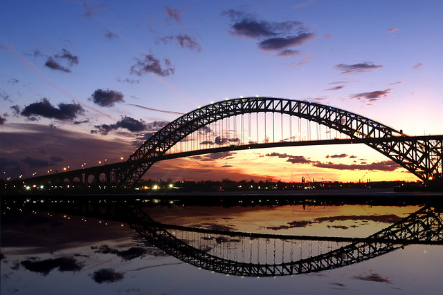
The Bayonne Bridge lies between Bayonne NJ and the borough of Staten Island of New York City, NY. It is a wonderful looking bridge with Red White and Blue lights along it’s arch since 9/11.
Some history from the Port Authority of NY and NJ:
Bayonne Bridge
70 Trantor Place, Staten Island, NY 10302
One of the longest steel arch bridges in the world, the Bayonne Bridge spans the Kill Van Kull to link Bayonne, New Jersey, with the Port Richmond area of Staten Island, New York. It is one of the most spectacular bridges in the metropolitan area, with a mid-span clearance of 150 feet that permits ocean-going vessels to use this entrance to Port Newark and the Elizabeth-Port Authority Marine Terminal without interference.
This bridge is an important part of the regional system of arterial highways. On Staten Island, it leads to the Verrazano-Narrows Bridge via the Martin Luther King, Jr. Expressway and the eastbound Staten Island Expressway (1-278). It also leads to the Goethals Bridge and Outerbridge Crossing via the westbound Staten Island Expressway.
The Bayonne Bridge was awarded the prize for the most beautiful steel arch bridge of 1931 by the American Institute for Steel Construction. The design of the arch features a slender, slightly tapered hyperbolic curve over the roadway. The trusses of the arch are a pleasing pattern of repetitive regular triangles.
|
Home -
Challenges -
Community -
League -
Photos -
Cameras -
Lenses -
Learn -
Help -
Terms of Use -
Privacy -
Top ^
DPChallenge, and website content and design, Copyright © 2001-2025 Challenging Technologies, LLC.
All digital photo copyrights belong to the photographers and may not be used without permission.
Current Server Time: 03/18/2025 10:41:08 AM EDT.